Magnitude 5.7 Earthquake Strikes Tibet: Shallow Depth Raises Concerns in Seismically Active Region
Recent quake follows smaller tremor, highlighting the region’s vulnerability and seismic volatility
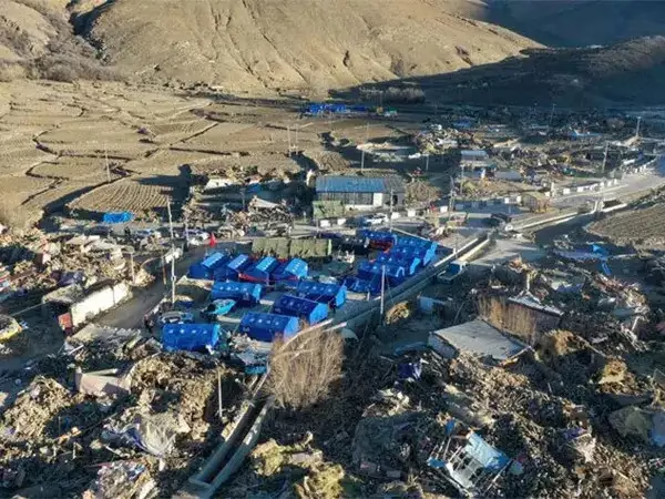
A magnitude 5.7 earthquake struck the Tibet Autonomous Region early Monday morning, prompting renewed concerns about the area’s seismic activity. According to the National Center for Seismology (NCS), the quake occurred at a shallow depth of 10 kilometers, a factor that significantly increases its potential for damage.
The tremor, which followed a magnitude 3.7 quake in the same area just days earlier, underscores the geological instability of the region. Though no major damage or casualties were immediately reported, seismologists warn that the shallow depth and proximity to fault lines make the Tibetan Plateau particularly susceptible to destructive ground movement.
Earthquake Details and Immediate Response
The 5.7 magnitude quake struck in the early hours of Monday morning, when most residents were likely indoors. Preliminary assessments indicate that the epicenter was located in a sparsely populated part of Tibet, which may have helped limit the human impact. However, the tremor was reportedly felt in several nearby counties, causing minor panic and prompting local authorities to initiate rapid damage assessments.
Emergency response teams were dispatched to inspect key infrastructure, including roads, bridges, and public buildings. As a precautionary measure, some schools and government offices temporarily suspended operations pending safety evaluations.
The NCS has been closely monitoring the region following the earlier 3.7 magnitude event. While the two quakes may not necessarily be related, experts note that a series of smaller tremors can sometimes precede a larger, more destructive earthquake—a phenomenon known as a foreshock sequence.
Understanding Shallow Earthquakes
Shallow earthquakes, typically defined as those occurring at depths less than 70 kilometers, are often more destructive than deeper quakes. This is because seismic waves generated by shallow quakes lose less energy before reaching the surface, resulting in stronger and more abrupt shaking.
The Tibet quake, at just 10 kilometers deep, fits this high-risk profile. Experts from various geological institutes emphasize that such shallow tremors, even at moderate magnitudes, can cause significant structural damage if they occur near populated areas.
Dr. Y. Chen, a seismologist at the Chinese Academy of Sciences (paraphrased), noted that shallow depth is one of the most critical factors in assessing earthquake risk. In regions like Tibet, where traditional architecture and remote infrastructure may not be built to modern seismic standards, the risk of damage and disruption is heightened.
A Seismically Active Region
The Tibetan Plateau is one of the most geologically complex and seismically active regions in the world. It sits at the convergence of the Indian and Eurasian tectonic plates, a collision zone responsible for forming the Himalayas.
This tectonic interaction not only created the world’s highest mountain range but also continues to generate substantial seismic activity. The immense pressure from the ongoing plate collision is periodically released in the form of earthquakes, making quakes like Monday’s a frequent, albeit unpredictable, phenomenon.
According to historical records and seismic data, the region has experienced several high-magnitude earthquakes over the past century. One of the most devastating occurred in 1950, when an 8.6 magnitude quake in the Assam-Tibet region claimed thousands of lives and caused widespread destruction across northeastern India and Tibet.
While Monday’s earthquake was far less powerful, its occurrence is a reminder of the persistent threat posed by the area’s active geology.
Earthquake Preparedness and Risk Mitigation
The frequency of seismic events in Tibet and surrounding regions has led both Chinese national and regional authorities to invest in improved earthquake preparedness and response systems. These include early warning systems, public education campaigns, and building code reforms aimed at improving structural resilience.
China’s Ministry of Emergency Management has developed protocols for rapid deployment of rescue operations, including coordination with military and local agencies. Drones, satellite imagery, and AI-based damage assessment tools have increasingly been used to enhance response times and accuracy.
However, challenges remain. Many parts of Tibet are remote and difficult to access, especially during adverse weather conditions. Limited transportation infrastructure and the vast, mountainous terrain can slow emergency response efforts, leaving some communities vulnerable in the aftermath of a quake.
In rural areas, where traditional building methods are still prevalent, homes may lack the structural integrity needed to withstand even moderate seismic events. Retrofitting existing structures and enforcing strict adherence to seismic-resistant building codes are ongoing challenges.
Global Context and Earthquake Trends
Globally, 2025 has already seen a number of significant seismic events. According to data from the United States Geological Survey (USGS), more than 40 earthquakes of magnitude 5.5 or greater have occurred since the beginning of the year. While not all result in significant damage, each serves as a reminder of the Earth’s dynamic nature and the importance of disaster preparedness.
The increasing urbanization of seismically active regions adds another layer of risk. More people living in high-risk zones means that the potential impact of each quake—economically and in terms of human life—can be profound.
Climate change, while not directly causing earthquakes, may influence secondary hazards such as landslides and glacial lake outburst floods, which can be triggered by seismic activity. In the Tibetan Plateau, where glaciers are retreating due to warming temperatures, the risk of such cascading disasters is a growing concern.
The Road Ahead: Building Resilience
In light of Monday’s quake, officials and experts are calling for continued vigilance and long-term investment in seismic resilience. This includes expanding early warning systems, increasing public awareness, and prioritizing resilient infrastructure in rural and urban planning.
The earthquake serves as both a cautionary tale and an opportunity for renewed focus on safety and sustainability in one of the world’s most geologically active regions.
While nature’s movements cannot be stopped, their consequences can be managed through preparedness, science, and community resilience. As Tibet recovers from the latest quake and braces for future ones, collaboration among scientists, government agencies, and local communities remains essential in reducing risk and protecting lives.
—
Did You Know?
The 1950 Assam-Tibet earthquake is one of the strongest ever recorded on land, with a magnitude of 8.6.
Shallow earthquakes, like Monday’s 5.7 magnitude quake, often cause more surface shaking than deeper ones.
The Indian and Eurasian tectonic plates converge at a rate of about 4-5 centimeters per year, a process that continues to shape the Himalayas and cause seismic activity.
—
Sources:
National Center for Seismology (NCS)
United States Geological Survey
(USGS)
Chinese Academy of Sciences
- Ministry of Emergency Management, China
Discover more from The Talkative Indian
Subscribe to get the latest posts sent to your email.


Leave a Reply